 |
| I loved this furry little guy! |
Tuesday, March 8, 2011
Blister is a winnah!
I love how the blister post is the most popular! I was happy when it bumped off the Paddy Post.
By the way, the big red blister is still there...
By the way, the big red blister is still there...
Some edited Grand Canyon pics!!
Thanks to the help of the awesome MC's in my office, I got a few of my favorite pictures edited today (sorry for the extreme lack of productivity today, Boss)!
Below are a few of my faves and then here is a link to a slide show with more.

Below are a few of my faves and then here is a link to a slide show with more.
Wednesday, March 2, 2011
Ok....now going back up (with pictures)
As I said before, we got a very early start back up the trail. This time we took the South Kaibab trail. When asking around, this trail is most commonly the one people take down because it is shorter but steeper, so they take Bright Angel up. South Kaibab is also supposed to be the more scenic route. So, we figured we could handle a little bit of steepness if that meant we would be up in 7 miles instead of 10. Sounded like a good idea at the bottom.

Beer
Paddy found out that drinking 2 20oz beers at sea level is not the same as drinking 2 20oz beers at 8,000 feet.
Grand Canyon Down updated with pictures!

As I discussed earlier, the snow was really coming down on Sunday night and through the morning. We woke up to blowing winds and lots of snow. We did not let that deter us! We headed down Bright Angel trail which is the longer of the 2 trails to the bottom. We were pretty much dressed for skiing. I think I had 5 shirts on. Oh, I can't forget the 45 pound packs we were both wearing with all of our camping gear. My back hurt the very second I put it on.
Bryce canyon
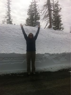
We made it to Bryce after an amazing drive in on scenic route 12. The snow is between 5 and, I don't know, 20 feet.
Paddy at the top of Escalante-Grand Staircase

In the land of no 3G
We camped out in Capitol Reef last night and are headed to Bryce Canyon today. It is absolutely beautiful.
Of course, I lost my adapter that lets me upload pictures from my camera to my iPad, so no pictures until either I find it or we get home. I will try to take more from my phone.
- Posted using BlogPress from my iPhone
Of course, I lost my adapter that lets me upload pictures from my camera to my iPad, so no pictures until either I find it or we get home. I will try to take more from my phone.
- Posted using BlogPress from my iPhone
Location:Loa,United States
Tuesday, March 1, 2011
The damage
It has Nu Skin on it, that is why it is shiny. Ouch. The one on the other toe is bigger, but it is just a water blister so it is not as impressive.

- Posted using BlogPress from my iPhone
- Posted using BlogPress from my iPhone
Subscribe to:
Posts (Atom)